Use of Thermal Imaging Technologies to Know the Influence of NbS on the Climate
Thermal imaging cameras are mainly used in the construction industry, for example when mapping heat losses from buildings. This technology is also very effectively used in mapping the temperature regime of the ecosystems and quick knowledge of not only the current state of damage to the landscape, but can also be used in learning the state of the temperature regime of the landscape, the intensity of transpiration of vegetation, but also thermoregulation. Thermal imaging can also be used in the impact of changes in the temperature regime of the ecosystem through the implementation of Nature bases solutions (NbS), for example, to know the air conditioning effect, and they could probably also be used in the research of changes in the temperature regime of the country in territories with realised NbS.
In order to understand the wide possibilities of using thermal imaging in the assessment of climatic characteristics of ecosystems and their damage, we present three examples of conventional land use in the current state and also three examples of the temperature regime of the ecosystem after the implementation of NBS. We will use these technologies very effectively in the assessment of the real impact of the realised NBS on the temperature regime of the country and also for the quantification of climatic characteristics.
Agricultural landscape with soybeans
In agricultural land, the earth's surface under the plants is dry, so the surface temperature reaches up to 40 °C. The temperature of the leaves is 10 °C lower. This difference in temperature indicates that the ecosystem does not have enough water for evaporation and that the plants suffer from a lack of moisture, which reduces their fertility. If there was a smaller temperature difference between the earth's surface and plant temperature, crops would have better conditions for higher plant yields.


Forest ecosystem with tree cover
The temperature regime of the forest stand clearly points to drought, as tree stumps near the earth's surface have a lower surface temperature. The upper parts of the tree trunks have a relatively high temperature, which confirms that the trees suffer from a lack of water for their growth. The thermal imaging image was taken on August 11, when the drought in Slovakia peaked with a long period without rain, and this was also reflected in the dryness in the forests. Trees suffer from a lack of water and therefore less evapotranspiration. This weakens photosynthesis in the forest ecosystem. The difference in surface temperature on one tree reaches up to 5 °C, which confirms a significant moisture deficit, which causes a decrease in the growth of wood mass and the economic result of the forest manager.
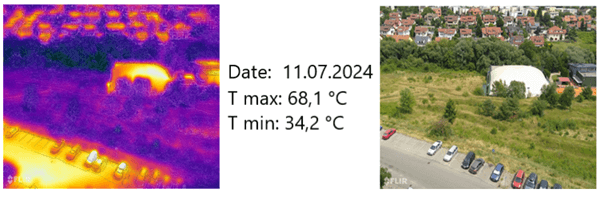
Urban landscape
Rainwater management in the locality is solved through drainage. By changing the management of rainwater and collecting it in the grass and in the root zone, the temperature could potentially be reduced by 10 degrees. This example points to the need to change rainwater management in spatial planning.
The other three examples point to the possibility of using thermal imaging to assess the impact of near-nature solutions (NBS).


Micropit dug by a wild boar
It is clearly seen how the collected rainwater dug by the wild boars causes cooling. The pit is about 0.3 m deep and rainwater is collected in it and does not drain away, causing cooling. The surface temperature without vegetation reaches up to 59 °C. This example shows how important every liter of rainwater is in the ecosystem.
Pond in the forest in autumn
Thermal image of a small body of water, taken on September 12. in colder weather. Here it is important to point out that bodies of water thermoregulate the earth's surface at times of low temperatures. This means that while the temperature in the surrounding vegetation dropped quite significantly to 9 °C, the water surface that heated up during the summer cools down more slowly in the fall, which means that it equalizes the temperatures. This is very important in the design of the landscape structure, so that the landscape cools down more slowly and also warms up when the temperatures change.


Contour infiltration lines
NBS soaking strips were implemented on a completely damaged site without vegetation more than 10 years ago. Restoring a damaged landscape through rainwater retention has regenerative effects.
We estimate that the temperature of the earth's surface without vegetation in the height of summer can reach around 60 degrees Celsius. By collecting all the rainwater on the site and evaporating it, the temperature according to the thermal imaging record reaches less than 38 degrees. This means that the implemented NBS on a site with an area of 3 hectares reduces the temperature by more than 20 degrees Celsius.
The quantification of the impact of rainwater harvesting through NbS (Nature-Based Solutions) provides valuable insights into the influence of landscape structure on the climate. NBS positively contributes to the restoration of damaged ecosystems and cools the surroundings with water vapor through vegetation. This is the focus of the LAND4CLIMATE project, which is leading efforts in the Košice region.
This article was written by Michal Kravčík and Danka Kravčíková from LAND4CLIMATE consortium partner NGO People and Water.
Publishing date: